Humanitarian Data Exchange

The Humanitarian Data Exchange (HDX) is an open platform for sharing data across crises and organisations. Launched in July 2014, the goal of HDX is to make humanitarian data easy to find and use for analysis. Our growing collection of datasets has been accessed by users in over 200 countries and territories. Watch this video to learn more.

HDX is managed by OCHA’s Centre for Humanitarian Data, which is located in The Hague. OCHA is part of the United Nations Secretariat and is responsible for bringing together humanitarian actors to ensure a coherent response to emergencies. The HDX team includes OCHA staff and a number of consultants who are based in North America, Europe and Africa.

[…]

We define humanitarian data as:

  1. data about the context in which a humanitarian crisis is occurring (e.g., baseline/development data, damage assessments, geospatial data)
  2. data about the people affected by the crisis and their needs
  3. data about the response by organisations and people seeking to help those who need assistance.

HDX uses an open-source software called CKAN for our technical back-end. You can find all of our code on GitHub.

Source: Welcome – Humanitarian Data Exchange

How Facebook is Using Machine Learning to Map the World Population

When it comes to knowing where humans around the world actually live, resources come in varying degrees of accuracy and sophistication.

Heavily urbanized and mature economies generally produce a wealth of up-to-date information on population density and granular demographic data. In rural Africa or fast-growing regions in the developing world, tracking methods cannot always keep up, or in some cases may be non-existent.

This is where new maps, produced by researchers at Facebook, come in. Building upon CIESIN’s Gridded Population of the World project, Facebook is using machine learning models on high-resolution satellite imagery to paint a definitive picture of human settlement around the world. Let’s zoom in.

Connecting the Dots

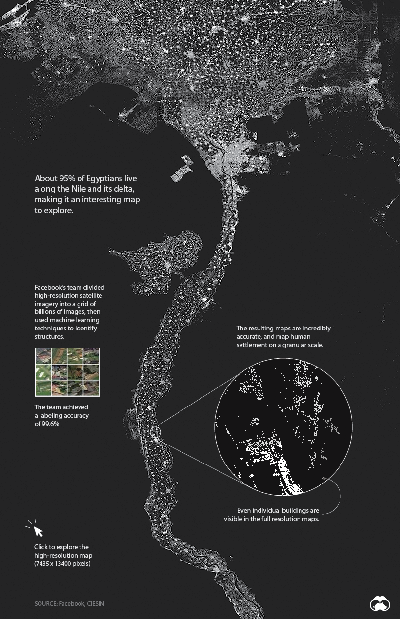
Will all other details stripped away, human settlement can form some interesting patterns. One of the most compelling examples is Egypt, where 95% of the population lives along the Nile River. Below, we can clearly see where people live, and where they don’t.

View the full-resolution version of this map.

facebook population density egypt map

While it is possible to use a tool like Google Earth to view nearly any location on the globe, the problem is analyzing the imagery at scale. This is where machine learning comes into play.

Finding the People in the Petabytes

High-resolution imagery of the entire globe takes up about 1.5 petabytes of storage, making the task of classifying the data extremely daunting. It’s only very recently that technology was up to the task of correctly identifying buildings within all those images.

To get the results we see today, researchers used process of elimination to discard locations that couldn’t contain a building, then ranked them based on the likelihood they could contain a building.

process of elimination map

Facebook identified structures at scale using a process called weakly supervised learning. After training the model using large batches of photos, then checking over the results, Facebook was able to reach a 99.6% labeling accuracy for positive examples.

Why it Matters

An accurate picture of where people live can be a matter of life and death.

For humanitarian agencies working in Africa, effectively distributing aid or vaccinating populations is still a challenge due to the lack of reliable maps and population density information. Researchers hope that these detailed maps will be used to save lives and improve living conditions in developing regions.

For example, Malawi is one of the world’s least urbanized countries, so finding its 19 million citizens is no easy task for people doing humanitarian work there. These maps clearly show where people live and allow organizations to create accurate population density estimates for specific areas.

rural malawi population pattern map

Visit the project page for a full explanation and to access the full database of country maps.

Source: How Facebook is Using Machine Learning to Map the World Population

UK made illegal copies and mismanaged Schengen travelers database, gave it away to unauthorised 3rd parties, both business and countries

Authorities in the United Kingdom have made unauthorized copies of data stored inside a EU database for tracking undocumented migrants, missing people, stolen cars, or suspected criminals.

Named the Schengen Information System (SIS), this is a EU-run database that stores information such as names, personal details, photographs, fingerprints, and arrest warrants for 500,000 non-EU citizens denied entry into Europe, over 100,000 missing people, and over 36,000 criminal suspects.

The database was created for the sole purpose of helping EU countries manage access to the passport-free Schengen travel zone.

The UK was granted access to this database in 2015, even if it’s not an official member of the Schengen zone.

2018 report revealed violations on the UK’s side

In May 2018, reporters from EU Observer obtained a secret EU report that highlighted years of violations in managing the SIS database by UK authorities.

According to the report, UK officials made copies of this database and stored it at airports and ports in unsafe conditions. Furthermore, by making copies, the UK was always working with outdated versions of the database.

This meant UK officials wouldn’t know in time if a person was removed from SIS, resulting in unnecessary detainments, or if a person was added to the database, allowing criminals to move through the UK and into the Schengen travel zone.

Furthermore, they also mismanaged and misused this data by providing unsanctioned access to this highly-sensitive and secret information to third-party contractors, including US companies (IBM, ATOS, CGI, and others).

The report expressed concerns that by doing so, the UK indirecly allowed contractors to copy this data as well, or allow US officials to request the database from a contractor under the US Patriot Act.

Source: UK made illegal copies and mismanaged Schengen travelers database | ZDNet

It’s official: Deploying Facebook’s ‘Like’ button on your website makes you a joint data slurper, puts you in GDPR danger

Organisations that deploy Facebook’s ubiquitous “Like” button on their websites risk falling foul of the General Data Protection Regulation following a landmark ruling by the European Court of Justice.

The EU’s highest court has decided that website owners can be held liable for data collection when using the so-called “social sharing” widgets.

The ruling (PDF) states that employing such widgets would make the organisation a joint data controller, along with Facebook – and judging by its recent record, you don’t want to be anywhere near Zuckerberg’s antisocial network when privacy regulators come a-calling.

‘Purposes of data processing’

According to the court, website owners “must provide, at the time of their collection, certain information to those visitors such as, for example, its identity and the purposes of the [data] processing”.

By extension, the ECJ’s decision also applies to services like Twitter and LinkedIn.

Facebook’s “Like” is far from an innocent expression of affection for a brand or a message: its primary purpose is to track individuals across websites, and permit data collection even when they are not explicitly using any of Facebook’s products.

[…]

On Monday, the ECJ ruled that Fashion ID could be considered a joint data controller “in respect of the collection and transmission to Facebook of the personal data of visitors to its website”.

The court added that it was not, in principle, “a controller in respect of the subsequent processing of those data carried out by Facebook alone”.

‘Consent’

“Thus, with regard to the case in which the data subject has given his or her consent, the Court holds that the operator of a website such as Fashion ID must obtain that prior consent (solely) in respect of operations for which it is the (joint) controller, namely the collection and transmission of the data,” the ECJ said.

The concept of “data controller” – the organisation responsible for deciding how the information collected online will be used – is a central tenet of both DPR and GDPR. The controller has more responsibilities than the data processor, who cannot change the purpose or use of the particular dataset. It is the controller, not the processor, who would be held accountable for any GDPR sins.

Source: It’s official: Deploying Facebook’s ‘Like’ button on your website makes you a joint data slurper • The Register

Scientists create contact lenses that zoom when you blink twice

scientists at the University of California San Diego have gone ahead and made it a reality. They’ve created a contact lens, controlled by eye movements, that can zoom in if you blink twice.

How is this possible? In the simplest of terms, the scientists measured the electrooculographic signals generated when eyes make specific movements (up, down, left, right, blink, double blink) and created a soft biomimetic lens that responds directly to those electric impulses. The lens created was able to change its focal length depending on the signals generated.

Therefore the lens could literally zoom in the blink of an eye.

Incredibly, the lens works regardless of whether the user can see or not. It’s not about the sight, it’s about the electricity produced by specific movements.

Source: Scientists create contact lenses that zoom when you blink twice – CNET

Small aircraft can be quite easily hacked to present wrong readings, change trim and autopilot settings – if someone has physical access to it.

Modern aircraft systems are becoming increasingly reliant on networked communications systems to display information to the pilot as well as control various systems aboard aircraft. Small aircraft typically maintain the direct mechanical linkage between the flight controls and the flight surface. However, electronic controls for flaps, trim, engine controls, and autopilot systems are becoming more common. This is similar to how most modern automobiles no longer have a physical connection between the throttle and the actuator that causes the engine to accelerate.

Before digital systems became common within aircraft instrumentation, the gauges and flight instruments would rely on mechanical and simple electrical controls that were directly connected to the source of the data they were displaying to the pilot. For example, the altitude and airspeed indicators would be connected to devices that measure the speed of airflow through a tube as well as the pressure outside the aircraft. In addition, the attitude and directional indicators would be powered by a vacuum source that drove a mechanical gyroscope. The flight surfaces would be directly connected to the pilot’s control stick or yoke—on larger aircraft, this connection would be via a hydraulic interface. Some flight surfaces, such as flaps and trim tabs, would have simple electrical connections that would directly turn motors on and off.

Modern aircraft use a network of electronics to translate signals from the various sensors and place this data onto a network to be interpreted by the appropriate instruments and displayed to the pilot. Together, the physical network, called a “vehicle bus,” and a common communications method called Controller Area Network (CAN) create the “CAN bus,” which serves as the central nervous system of a vehicle using this method. In avionics, these systems provide the foundation of control systems and sensor systems and collect data such as altitude, airspeed, and engine parameters such as fuel level and oil pressure, then display them to the pilot.

After performing a thorough investigation on two commercially available avionics systems, Rapid7 demonstrated that it was possible for a malicious individual to send false data to these systems, given some level of physical access to a small aircraft’s wiring. Such an attacker could attach a device—or co-opt an existing attached device—to an avionics CAN bus in order to inject false measurements and communicate them to the pilot. These false measurements may include the following:

  • Incorrect engine telemetry readings

  • Incorrect compass and attitude data

  • Incorrect altitude, airspeed, and angle of attack (AoA) data

In some cases, unauthenticated commands could also be injected into the CAN bus to enable or disable autopilot or inject false measurements to manipulate the autopilot’s responses. A pilot relying on these instrument readings would not be able to tell the difference between false data and legitimate readings, so this could result in an emergency landing or a catastrophic loss of control of an affected aircraft.

While the impact of such an attack could be dire, we want to emphasize that this attack requires physical access, something that is highly regulated and controlled in the aviation sector. While we believe that relying wholly on physical access controls is unwise, such controls do make it much more difficult for an attacker to access the CAN bus and take control of the avionics systems.

Source: [Security Research] CAN Bus Network Integrity in Avionics Systems | Rapid7