In recent years you’ve probably seen a couple of photos of tablets and smartphones strapped to the armor of soldiers, especially US Special Forces. The primary app loaded on most of those devices is ATAK or Android Tactical Assault Kit. It allows the soldier to view and share geospatial information, like friendly and enemy positions, danger areas, casualties, etc. As a way of working with geospatial information, its civilian applications became apparent, such as firefighting and law-enforcement, so CivTAK/ATAK-Civ was created and open sourced in 2020. Since ATAK-Civ was intended for those not carrying military-issued weapons, the acronym magically become the Android Team Awareness Kit. This caught the attention of the open source community, so today we’ll dive into the growing TAK ecosystem, its quirks, and potential use cases.
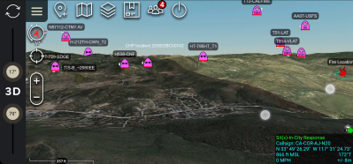
Tracking firefighting aircraft in 3D space using ADS-B (Credit: The TAK Syndicate)
The TAK ecosystem includes ATAK for Android, iTAK for iOS, WinTAK for Windows, and a growing number of servers, plugins, and tools to extend functionality. At the heart of TAK lies the Cursor on Target (CoT) protocol, an XML or Protobuf-based message format used to share information between clients and servers. This can include a “target’s” location, area, and route information, sensor data, text messages, or medevac information, to name a few. Clients, like ATAK, can process this information as required, and also generate CoT data to share with other clients. A TAK client can also be a sensor node, or a simple node-Red flow. This means the TAK can be a really powerful tool for monitoring, tracking, or controlling the things around you.
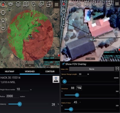
Standalone tools: Checking line-of-sight and camera coverage
ATAK is a powerful mapping tool on its own. It can display and plot information on a 3D map, calculate a heading to a target, set up a geofence, and serve as a messaging app between team members. Besides using it for outdoor navigation, I’ve used two other built-in mapping features extensively. Viewshed allows you to plan wireless node locations, and check line-of-sight their line-of-sight coverage. The “sensor” (camera) markers are handy for planning coverage of CCTV installations. However, ATAK starts to truly shine when you add plugins to extend features, and link clients in a network to share information.
Networking
To allow networking between clients, you either need to set up a multicast network or a central server that all the clients connect to. A popular option for multicast communication is to set up a free ZeroTier VPN, or any other VPN. For client-server topologies, there are several open source TAK servers available that can be installed on a Raspberry Pi or any other machine, including the official TAK server that was recently open sourced on GitHub. FreeTakServer can be extended with its built-in API and optional Node-RED server, and includes an easy-to-use “zero-touch” installer. Taky, is another lightweight Python-based server. All these servers also include data package servers, for distributing larger info packs to clients.
Plugins
If an internet connection is not available where you are going, there are several off-grid networking plugins available. HAMMER acts as an audio modem to send CoTs using cheap Baofeng radios. Atak-forwarder works with LoRa-based Meshtastic radios, or you can use APRS-TAK with ham radios.
Plugins can also pull data from other sources, like ADSB data from an RTL-SDR, or the video feed and location information from a drone. Many of the currently available plugins are not open source and are only available through the TAK.gov website after agreeing to terms and conditions from the US federal government. Fortunately, this means there is a lot of space for open source alternatives to grow.
For further exploration, the team behind the FreeTAK server maintains an extensive list of TAK-related tools, plugins, info sources, and hardware.
Tips to get started
At the time of writing, ATAK is significantly more mature than iTAK and WinTAK, so it’s the best option if you want to start exploring. iTAK is actually a bit easier to start using immediately, but it’s missing a lot of features and can’t load plugins.
Opening ATAK on Android for the first time will quickly become apparent that it is not exactly intuitive to use. I won’t bore you with a complete tutorial but will share a couple of tips I’ve found helpful. Firstly, RTFM. The usage of many of the features and tools is not self-evident, so the included PDF manual (Settings > Support > ATAK Documents) might come in handy. There is also a long list of settings to customize, which are a lot easier to navigate with the search function in the top bar of the Settings menu.
No maps are included in ATAK by default, so download and import [Joshua Fuller]’s ATAK-Maps package. This gives ATAK an extensive list of map sources to work with, including Google Maps and OpenStreetMaps. ATAK can also cache maps and imagery for offline use. ATAK only has low-resolution elevation data included by default, but you can download and import more detailed elevation data from the USGS website.